
When you’re new to hiking or returning to the trails after an extended break, getting started can be overwhelming, and heading straight to the mountains can feel daunting. Rest assured, you don’t have to tackle North Carolina’s hardest trails right away to reap the physical and mental health benefits of hiking.
The best way to prepare for hiking is to start with walking. After all, there are many places within 50 miles of Charlotte to walk and enjoy fresh air and green spaces. Luckily, you don’t have to go that far. There are plenty of greenway trails right in Mecklenburg County, which includes Charlotte and surrounding cities and towns.
Greenways are undeveloped land in urban and rural communities designed to preserve green space for recreational use, environmental protection or both. They feature developed pathways for people to walk, run or ride a bike on, and are often positioned between neighborhoods and communities as a way to travel between them without the use of a car.
There are many benefits to greenways. They offer a natural space to decompress, enjoy nature and engage in physical activities. Locals might use a greenway to commute to work by foot or bike, reducing road congestion. This benefits cities by reducing vehicle traffic, pollution and individuals’ carbon footprints.
We love the greenways in Mecklenburg County because they’re plentiful, free to access and offer a peaceful place to take a break in a busy metropolitan area.
Mecklenburg County is home to 15 greenways offering more than 60 miles (and growing!) of developed trails for Charlotte-area residents and visitors to explore. The trails vary in length and are a mix of pavement, gravel and dirt making them ideal for all fitness levels. Each greenway below is linked to a trail map and trailhead parking is linked to addresses or pinned locations on Google Maps.
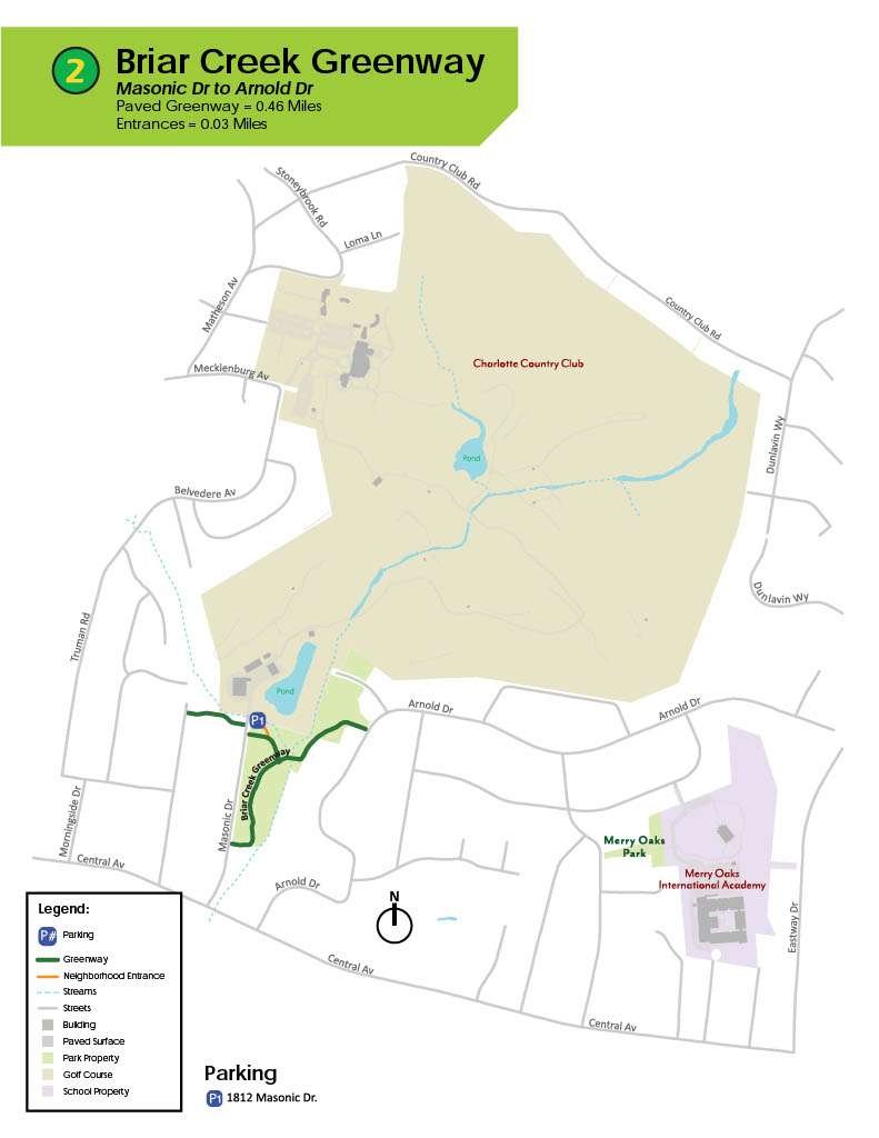
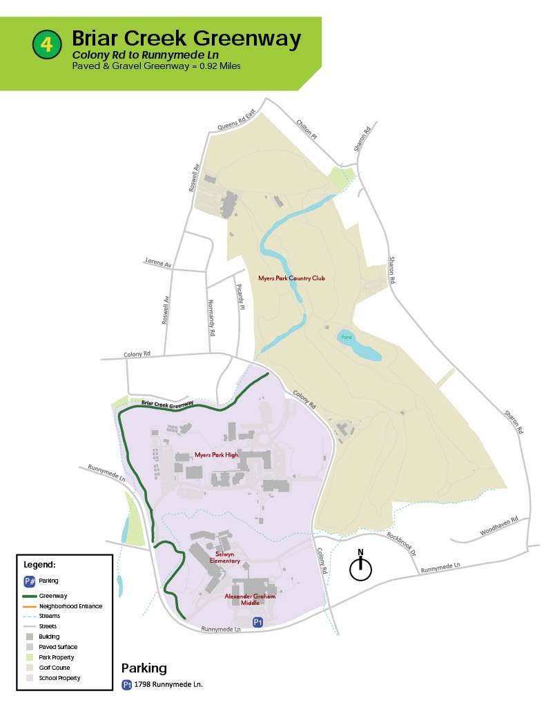
Briar Creek Greenway is a 1.9-mile out-and-back path located in Charlotte that travels through forest and wetlands along Briar Creek. This paved and gravel trail is popular for walking, running and biking. It’s relatively flat making it an easy effort and offers benches for resting, people watching, wildlife spotting or bodyweight exercises. This greenway is dog-friendly, but dogs must be on a leash.
Briar Creek has two access points: Randolph Road near the Mint Museum, and Meadowbrook Road. The Randolph Road trailhead has plenty of free parking, whereas Meadowbrook Road is a residential street and parking may be limited.
Bus route number(s) within a 20 min. walk of a Greenway entrance: 9 & 54
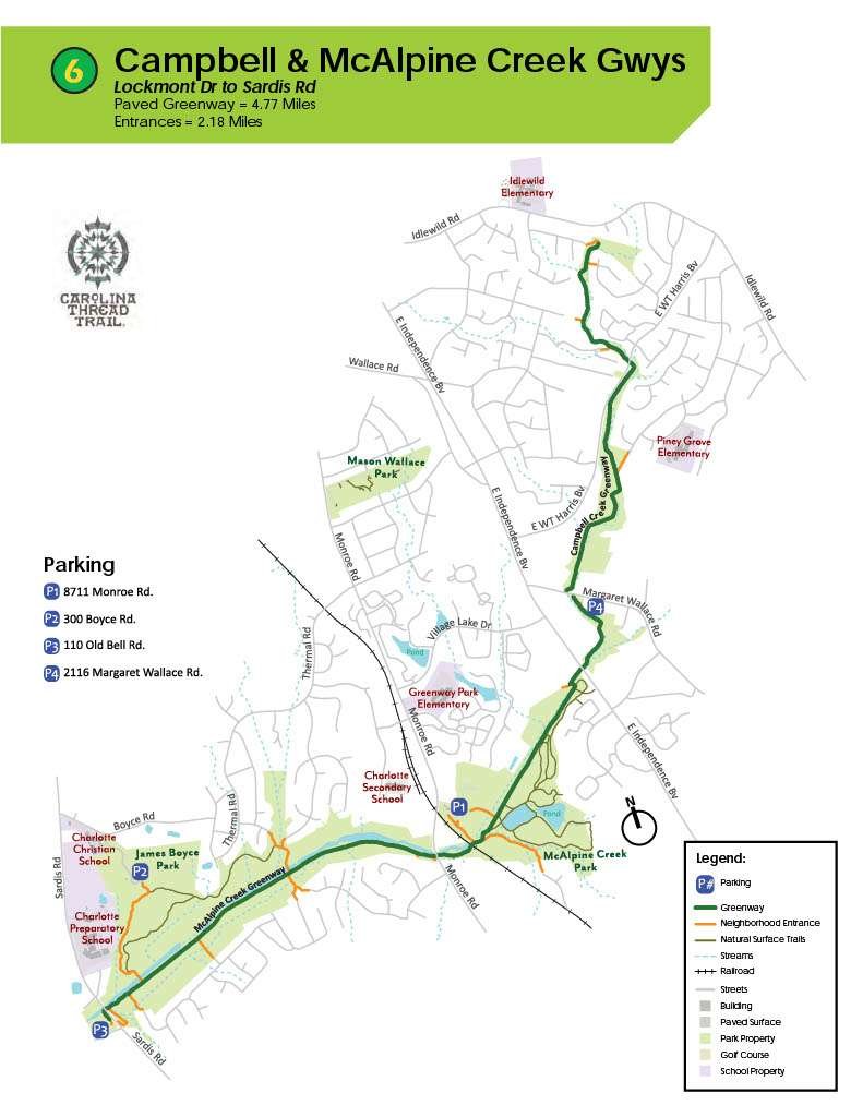
The Campbell Creek and Upper McAlpine Creek Greenways combine to offer an 8.3-mile out-and-back trail in southeast Charlotte, just north of the town of Matthews. These trails are popular for hiking, biking and running and are open to dogs that are on leash. This path features forest, wildflowers and wildlife sightings, so it’s great when you’re seeking peace and beauty outdoors.
The southern end of Upper McAlpine Creek is easily accessed by a parking lot and off Sardis Rd. To hop on in the middle, park at McAlpine Creek Park or start at the connector to Campbell Creek—parking is a small lot on Margaret Wallace Road, across from the fire station. Blink and you’ll miss it!
Bus route number(s) within a 20 min. walk of a Greenway entrance: 17 & 27
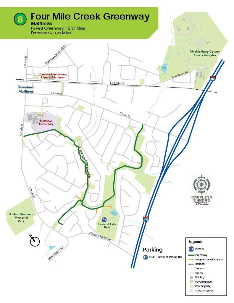
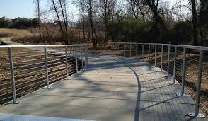
Charlotte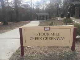 ’s Four Mile Creek Greenway offers a paved trail and boardwalk through the forest and wetlands surrounding Fourmile Creek. Don’t be confused by the name: this greenway is approximately 1.6 miles end-to-end (3.2 miles out-and-back) and is ideal for hiking, cycling and wildlife viewing. We love the different vibe the boardwalk offers, and dogs are welcome on leashes on this greenway.
Hop on at the west end of Four Mile Creek Greenway where it meets Lower McAlpine Greenway. There’s a parking lot on Johnston Road where you can take a connector to the main trail. Or, at the eastern end of the trail, there is a parking long at the corner of Rea Road and Bevington Place. This parking lot has a public restroom. For locals living nearby, neighborhood access to the trail can be found at the end of Radner Lane and near Stanton Green Court.
Bus route number(s) within a 20 min. walk of a Greenway entrance: 11,22 &54
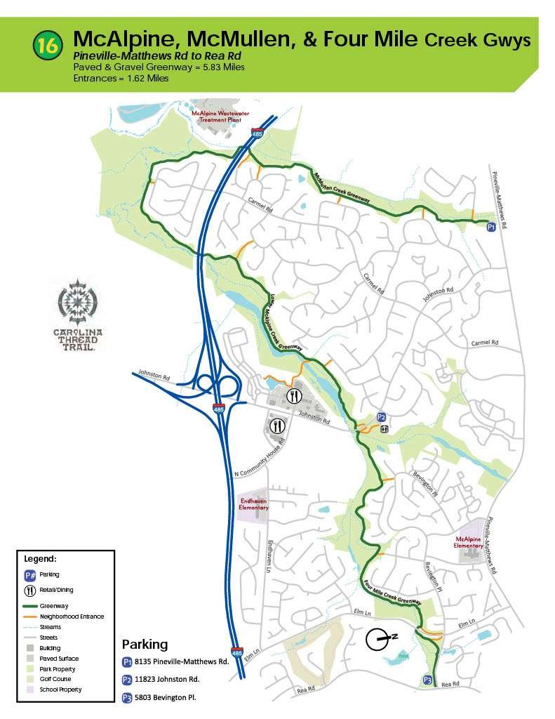
Picking up at Four Mile Creek Greenway, Lower McAlpine and McMullen Creek Greenways connect to offer just over four miles one way or 8.3 miles out-and-back. Located in south Charlotte, the trail is composed of asphalt and gravel and is popular with walkers, trail runners and cyclists, but users can find peace during quieter times of the day. Dogs are welcome and may be unleashed in some areas.
Park in the lot on Johnston Road at the east end or a lot off Pineville-Matthews Road at the northwest end.
Bus route number(s) within a 20 min. walk of a Greenway entrance: 19,51,43
The Irwin Creek and Stewart Creek Greenways offer 3.2 miles out-and back and are connected to other trails in uptown Charlotte making it easy to extend your mileage when you’re ready. Surfaces are gravel/crushed stone, sidewalk and pavement and are shared by walkers, hikers and cyclists looking to enjoy views of the creek and wildlife. Dogs are permitted on leash.
Park near Ray’s Splash Planet to hop on Irwin Creek Greenway at the east end or at the end of S Bruns Ave, near Seversville Park to hop on at the west side on Stewart Creek Greenway.
Bus route number(s) within a 20 min. walk of a Greenway entrance: 2,10,30
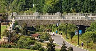
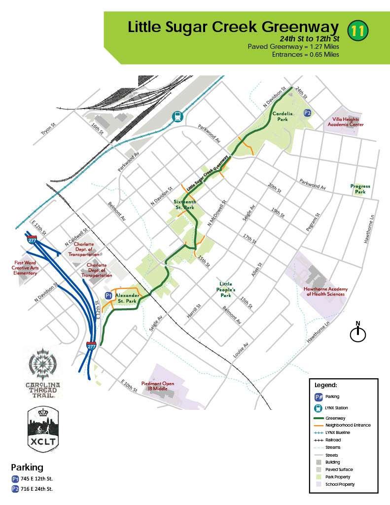
Little Sugar Creek Greenway is made up of five distinct sections and will feature more than 19 miles of trails when complete. Enjoy paved trails through forested areas and along Little Sugar Creek for a gentle or brisk walk, and bring your dog for company! Currently, the five sections are Cordelia Park to 12th Street, East 7th Street to Morehead Street, Morehead Street to Brandywine Road, Tyvola Road to Huntingtowne Farms Park and Huntingtowne Farms Park to I-485.
There are a variety of entry points depending on the section of Little Sugar Creek you’d like to hike or walk. At the northernmost end, park in Elizabeth Park near Second Ward. At the southern terminus, park at the Carolina Pavilion shopping mall and hop on the South Boulevard Connector to get to Little Sugar Creek Greenway.
Bus route number(s) within a 20 min. walk of a Greenway entrance: 6,9,&17
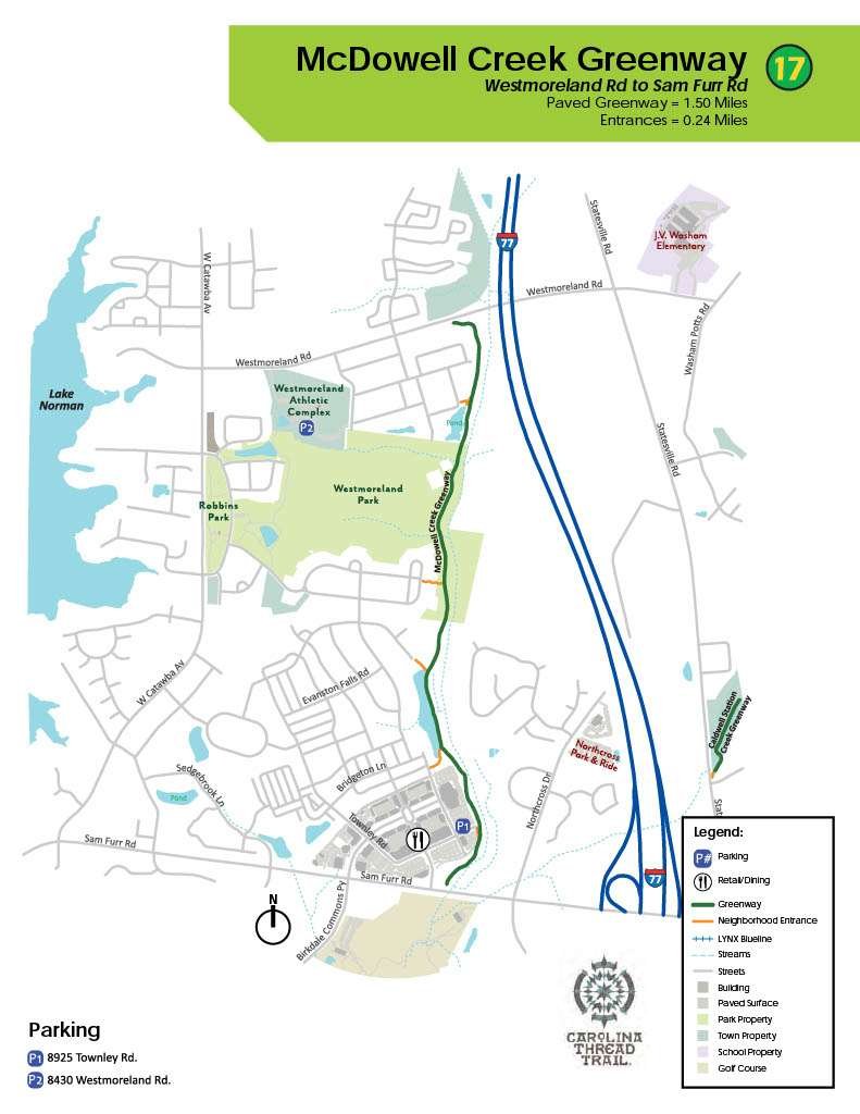
Located north of Charlotte, McDowell Creek Greenway is a fully paved 2.8-mile out-and-back that offers some gentle hills to prepare for hiking elevation. This greenway connects Cornelius neighborhoods to Birkdale Village in Huntersville. Enjoy the views of a small pond, and take a break on one of the benches along the trail. Turn this trail into a loop using the sidewalks along Westmoreland Road and West Catawba Ave before turning into the neighborhoods behind Robbins Park and making your way back to Birkdale Village.
Parking at Birkdale behind Fleet Feet Huntersville is the easiest way to access the trail.
Bus route number(s) within a 20 min. walk of a Greenway entrance: 97
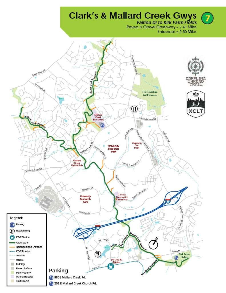
Mecklenburg County’s longest greenway is Mallard Creek and Clarks Creek. These connected trails stretch more than 7.4 miles end-to-end. Fun fact: Mallard Creek Greenway is part of the Cross-Charlotte Trail that will eventually extend to 26 miles in length and connect the SC/NC state line to Cabarrus County. This greenway offers benches and picnic tables for resting and recharging when you stroll this paved and gravel path.
Both Mallard Greek and Clarks Creek Greenways feature a half-dozen connecting trails to neighborhoods. We recommend parking at the Winchester Playground or the TMSA Charlotte Secondary School near the Mallard Creek and Clarks Creek junction.
Bus route number(s) within a 20 min. walk of a Greenway entrance: 50,54,&59
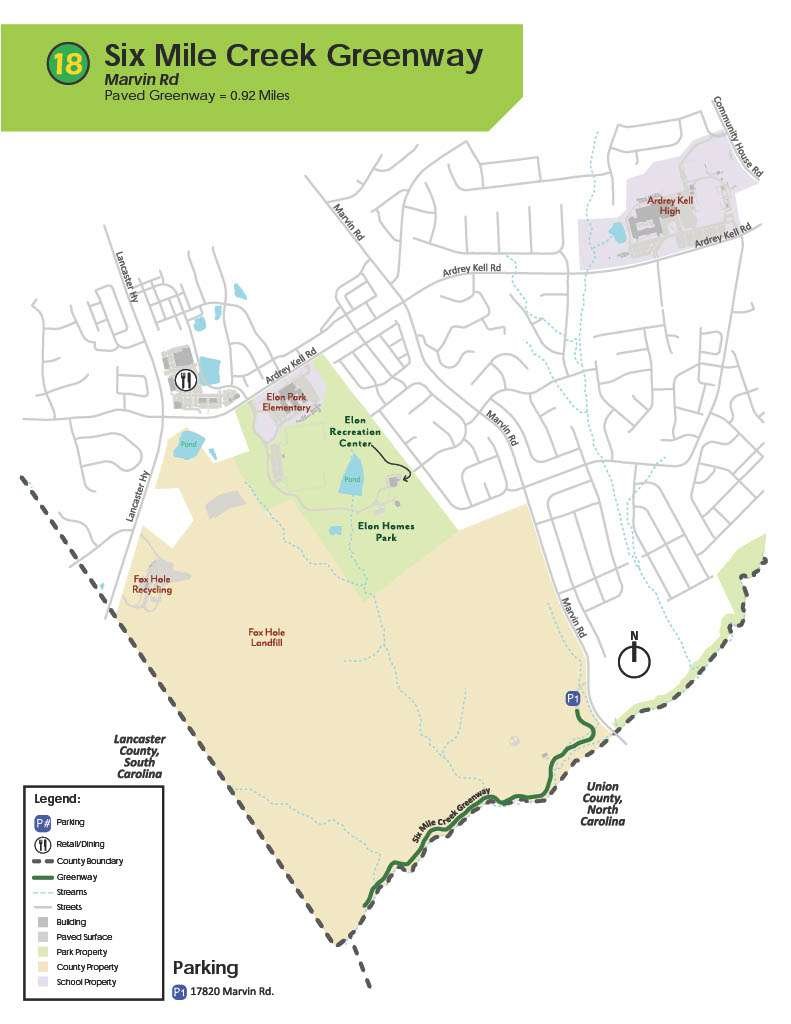
Located in Charlotte, near Pineville, Six Mile Creek Greenway is 1.8 miles out-and-back. The trail is paved and shady, but it’s worth noting that some lower sections are prone to flooding after heavy rainfall. Six Mile is a great place to walk, bike, walk your dog and spot wildlife. Eventually, this trail will connect to neighborhoods in Mecklenburg and Union counties.
Because Six Mile Creek Greenway is truly an out-and-back that doesn’t connect to other trails, your only option is to park in the lot at the trailhead off Patterson Road.
Bus route number(s) within a 20 min. walk of a Greenway entrance: NONE
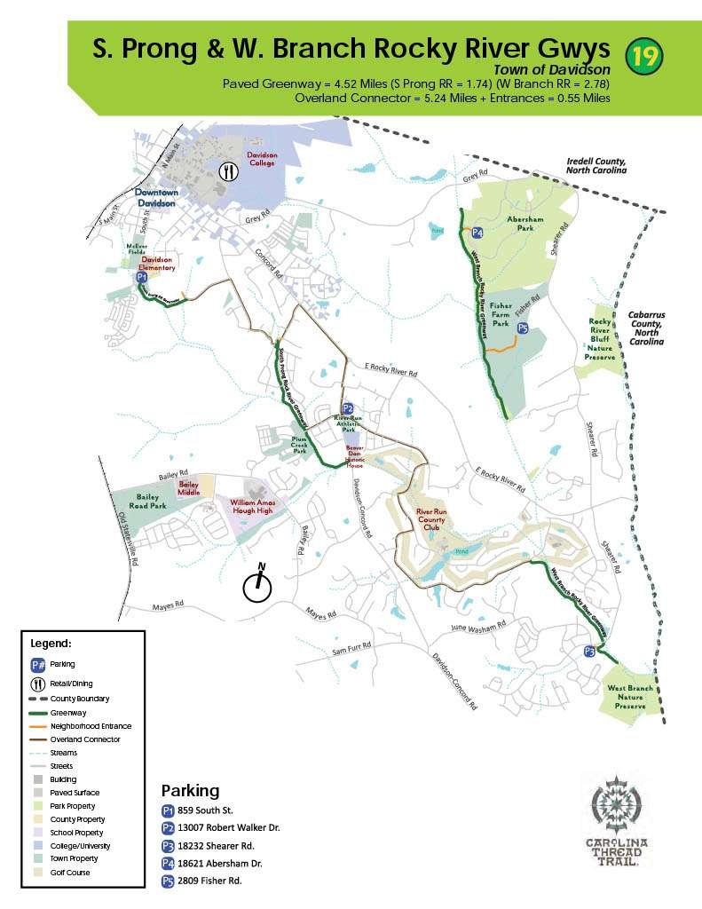
Davidson residents and visitors have access to more than eight miles of trails through South Prong Rocky River Greenway and West Branch Rocky River Greenway with plenty of connector trails that link the greenways to neighborhoods and downtown Davidson. These greenways are dog friendly and visitors are treated to wooden bridges, boardwalks and paved surfaces.
Parking is available in Abersham Park at the north end of the West Branch Rocky River Greenway. To hop on South Prong Rocky River Greenway, park at Davidson Elementary School or River Run Athletic Park.
Bus route number(s) within a 20 min. walk of a Greenway entrance: NONE
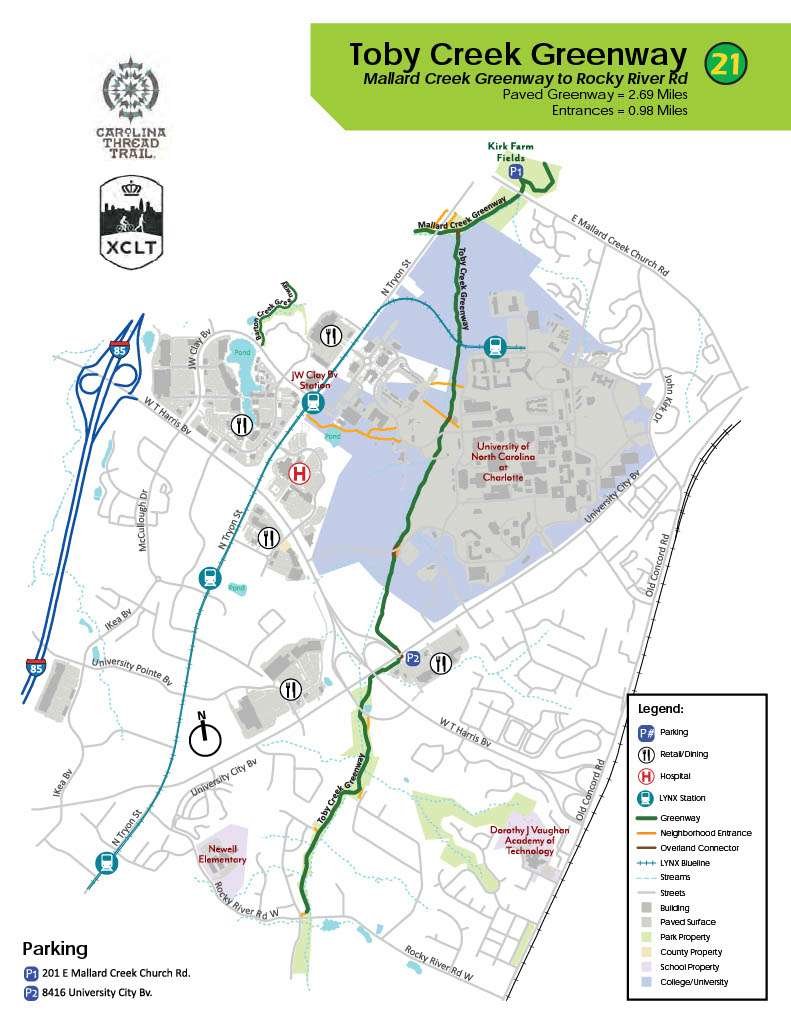
Toby Creek Greenway travels through the forested area south of UNC Charlotte and connects the campus to Mallard Creek Greenway at its northern end. This paved trail is 5.8 miles out-and-back and does include multiple road crossings, so it’s important to be vigilant of vehicle traffic. Walkers, runners and cyclists frequently use Toby Creek Greenway, but it’s possible to enjoy some solitude at quieter times of the day.
We recommend parking at Kirk Farm Park and connecting to Toby Creek Greenway via a short section of Mallard Creek Greenway or at Lowe’s off Chancellor Park Drive and accessing the trail from there.
Bus route number(s) within a 20 min. walk of a Greenway entrance: 29,47x &59
12. Taggart Creek Greenway
Taggart Creek Greenway is a short, 1-mile out-and-back trail along Taggart Creek off Billy Graham Parkway, near Charlotte Douglas International Airport. This fully paved trail skirts around a neighborhood and is close to Southview Recreation Center, so it’s easy to add mileage walking nearby residential streets.
Parallel parking spaces along Innovation Drive get you closest to the north end of the trailhead for Taggart Creek Greenway. Or, park at Southview Recreation Center and access the trail via a short walk along Burnett Avenue.
Bus route number(s) within a 20 min. walk of a Greenway entrance: 10 & 235
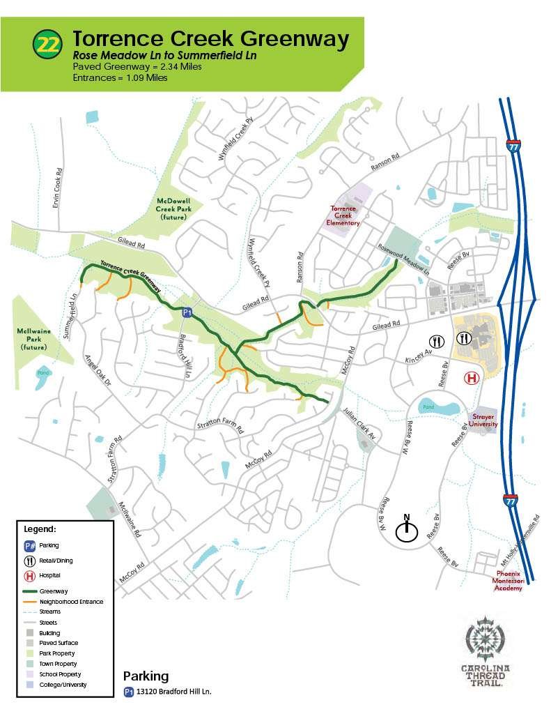
Nestled in Huntersville, Torrence Creek Greenway is a quiet, paved 2.8-mile out-and-back trail running through woods along Gilead Road with multiple connecting trails to nearby neighborhoods. Short sections of the greenway feature boardwalks meandering through wetlands, and the trail can get muddy after heavy rainfall.
We recommend parking at Rosedale Nature Park and walking across Rosewood Meadow Lane to access the trailhead for North Branch Torrence Creek Greenway. You can also park in one of the neighborhoods with a connector trail.
Bus route number(s) within a 20 min. walk of a Greenway entrance: NONE
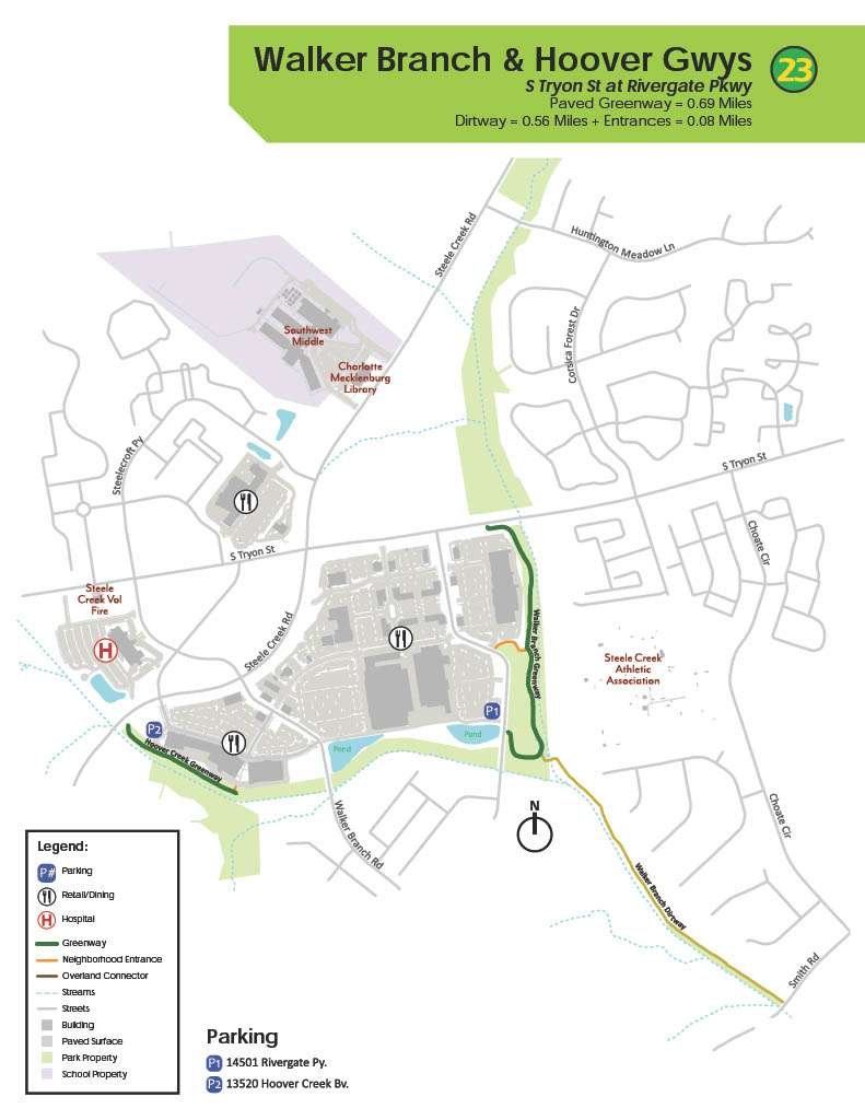
Walker Branch Greenway is a 1.9-mile out-and-back off South Tryon Street behind the Rivergate Mall. It has a handful of trailheads from the shopping area’s parking lot and nearby neighborhoods. Hoover Creek Greenway is on the other side of the Rivergate Mall running behind the Ulta, Home Goods and Kohl’s. Despite being close to each other, these greenway trails are not connected.
For Hoover Creek Greenway we recommend parking in front of the shopping center and walking around the building to access the trail. Park at Best Buy to access the trailhead for Walker Branch Greenway.
Bus route number(s) within a 20 min. walk of a Greenway entrance: 16
Long Creek Greenway is a new 1.5-mile paved path in north Charlotte that was designed and constructed in collaboration with a Charlotte-Mecklenburg Storm Water Services Stream Improvement Project. Phase 1 of this project connects pedestrians to Long Creek Club Drive, Reames Road, Secretariat Drive, Northlake Center Parkway, Bayview Parkway and Treyburn Drive. Two additional phases are in the works to extend the trail an additional 4.8 miles.
Long Creek Greenway can be accessed by parking near the Northcrest Shopping Center adjacent to Target Shopping.
Bus route number(s) within a 20 min. walk of a Greenway entrance: 7, 53X & 99
It’s worth noting that different resources may list different mileage for Mecklenburg County’s greenway trails. However, the majority should land within a few tenths of a mile of each other.
When we say that a trail is “8.3 miles out-and-back,” this accounts for the total mileage you can get when you start at one end, walk to the other and then head back to where you started. Of course, you don’t have to walk the entire trail, and you might even start somewhere in the middle!
As you increase your fitness and endurance, it helps to have a clear picture of the total mileage you could get on any of Mecklenburg County’s greenway trails.
While greenways and parks are safe, incidents can happen. Here are four safety tips for greenways, parks and trails:
Speaking of hiking with friends, MyOutdoorJoy invites you to join us for Greenway Gatherings on Tuesday evenings. If you’re looking for a low-key way to de-stress and enjoy nature with like-minded people, join us for 45 to 60 minutes of walking and gentle hiking on a variety of trails in the Charlotte area, including the Mecklenburg County greenways. All you need is a comfortable pair of shoes!
Greenway Gatherings is open to MyOutdoorJoy members and non-members and we have safety covered for all participants. Check the MyOutdoorJoy calendar to sign up for the next Greenway Gathering.
We’ll see you on the trails!

If the phrase don’t judge a book by its cover was an image, it would be me. I am an avid outdoorsman that loves to teach people about the outdoors whether its specific skills like camping or just exposing people to different outdoor activities. I have been in the skilled outdoors space for 30+ years and have been loving it forever. If not for friends, I would still be focused on my corporate career instead of focusing on the things I love to do. My goal is to hit the Scottish highlands in the next 2 years.